In-house product · Geodata & routing
RouMeGo plans routes around personal preferences, not distance alone.
RouMeGo creates walking, hiking and cycling routes based on individual preferences. Nature, water, quiet surroundings, discovery and an acceptable detour all influence the plan, turning routing into a personal trade-off rather than a shortest-path search.
Product concept, geodata processing, routing, web application and native Android app by ProWebSolutions.
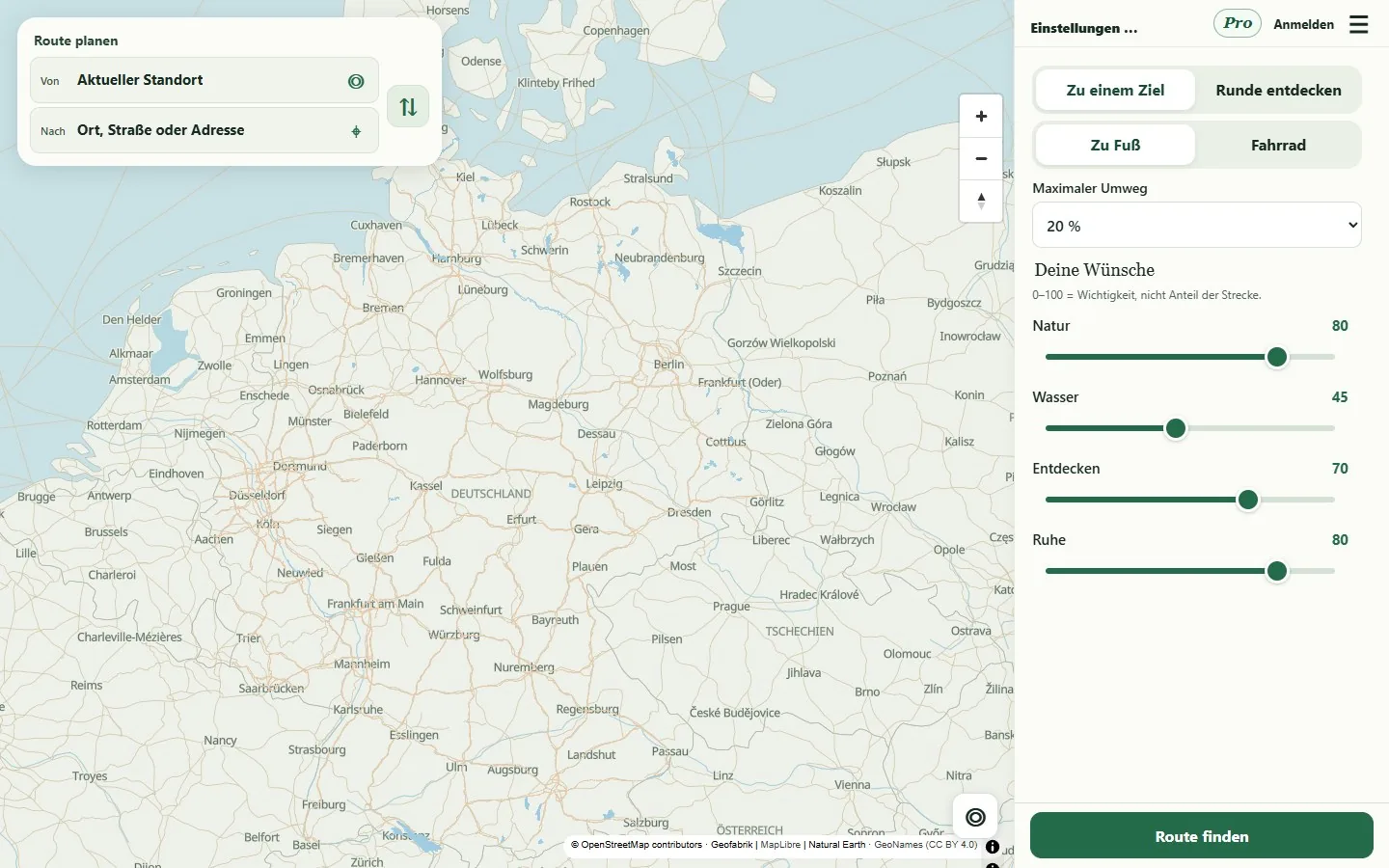
Personal criteria become part of the route
Conventional route planners often optimise mainly for time or distance. RouMeGo takes a different approach. Users can weight criteria such as nature, proximity to water, quiet sections or opportunities to discover new places. They also decide how much of a detour remains acceptable compared with a direct route.
Planning uses OpenStreetMap data and a custom scoring system for possible paths. This allows the product to compare alternatives rather than merely presenting an existing standard route. The result is designed to reflect the chosen activity and the user’s priorities.
Round trips without rigid repetition rules
For walks or tours, RouMeGo can plan a round trip from a desired duration. Previously used path segments receive a penalty so the route does not return along the same way unnecessarily. The rule remains flexible: when geography or the available path network offers no useful alternative, a segment can still be reused.
That trade-off is more practical than an absolute ban. A completely repetition-free round trip may be impossible or significantly worse in real conditions. Routing must therefore consider preferences, duration, detour and the available network together.
Discovering places and recording visits
Points of interest are enriched with data from OpenStreetMap, Wikidata and Wikipedia, connecting the route with knowledge about the surrounding area. Visits can be identified from proximity, and users can upload their own photos for places.
Behind that experience is a data pipeline for German geodata and knowledge data that is updated regularly through automated processes. The routing base and place information are treated as an actively maintained product resource rather than a one-off import.
Web application and native Android navigation
RouMeGo is available as a web application and a native Android app, with maps rendered through MapLibre. An earlier hybrid app approach was abandoned after measurement: the native implementation reduced CPU use by more than 20 per cent, used less memory and responded more quickly.
Navigation also accounts for weak GPS reception. The app retains the required map and surrounding data for temporary offline use so an active route can continue or be recalculated. ProWebSolutions combines routing logic, data updates, map interaction and mobile runtime optimisation in one product.
Relevant engineering services
The capabilities demonstrated by this project.
Related current work
Explore related ProWebSolutions products.
In-house product · Personal AI
Mementri
A personal AI memory that processes voice and text entries and connects tasks, ideas, projects and memories to their sources.
- Role
- Product concept, system architecture, development, AI infrastructure and ongoing operation.

In-house product · Browser monitoring
StoreVigil
Browser-based monitoring for websites and stores with visual issue location, repeated checks and distributed workers.
- Role
- Product concept, browser automation, monitoring architecture and ongoing operation.

In-house product · Music & events
DepositoLive
Music, community and event platform with QR-linked albums, artist posts, tickets and payment workflows.
- Role
- Product concept, platform architecture, development, payment and ticketing processes.